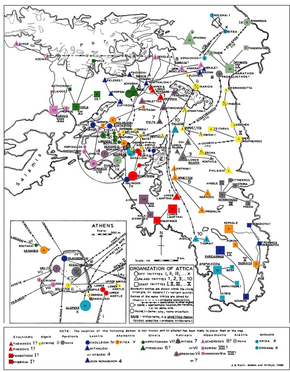
ANAGYROUS (Ἀναγυροῦς), Attic paralia deme of Erechtheis phyle. The location of Anagyrous has been firmly established to be at the modern Vari, on a small plain just to the east of Cape Zoster and the south end of Mount Hymettos. Anagyrous was well-established around a deme center. The remains of a fortification dating to the 5th century BC can still be seen atop a small hill to the west of the modern town. This fortification probably served as a signalling station, since it has a clear line of sight to Peiraieus in the north and most of the Attic coast to the south as far as Athens.
Pausanias mentions at this place a temple of the Mother of the Gods. On the slopes of Hymettos is a grotto of Nymphs which was still in excellent condition in the early 19th century. There is also evidence of theater activities as early as 440-431 BC. Euripides may have won an early victory there.
The deme took its name from a local Hero, Anagyros, who had a precint in Anagyrous. The Hero is largely known for punishing a farmer who cut down his sacred grove: “the old man who lived near by and cut down trees of the grove was punished by the Hero Anagyrus” and also “Anagyrasian divinity’: the saying is used when a whole household is overwhelmed of misfortunes. The story goes that a farmer in the deme of the Anagyriasian was accused of violating the neighbouring altar, whereupon ha was visited with terrible calamities.” The story is told in the lost play Anagyrus by Diphilos and the play of the same name by Aristophanes, of which only fragments remain.
Anagyros is also the name for the stinking bean trefoil (Anagyris foetida): “stir up anagyrus’: Anagyrous is an Attic township where there grows a bad-smelling plant, also called anagyrus. So from this comes the proverb applied to people who stir up things or someone to bad effect on themselves. But some say there was a Hero Anagyrous who utterly obliterated the neighboring households after they tried to profanate his hero-shrine.”
The blossom smells strongly of cabbage, and all parts of the plant were used medicinally, particularly in cases surrounding childbirth problems.
(Strab. IX 1, 24; Paus. 1.31.1; Harpocrat., Suda, Steph. B. ; Zen. Proverbs 2.55; Pliny NH 27.13; Her. 8.93)
CHOLLEIDAI (Χολλεῖδαι), Attic mesogeia deme of Leontis phyle. It is supposed to have been near the Grotto of the Nymphs, situated at the southern end of Mt. Hymettus, and about three miles from Vári by the road.
Kholleidai is best known as the deme of Dikaiopolis, the hero of Aristophanes’ Acharnians.
From the inscriptions in the Nymphs’ cave, we learn that it was dedicated to the Nymphs and the other rustic deities by Archedemus of Pherae , who had been enrolled in the deme of Cholleidai. Hence it is inferred that the grotto was, in all probability, situated in this deme.
(Harpocr.; Suda; Steph.; Schol. ad Aristoph. Acharn. 404)
THORAI (Θοραί), Attic paralia deme of Antiochis phyle. The general location of Thorai is known from Strabo, who placed it on the coast between Anagyrous and Lamptrai. It was on the southwestern coast of Attica, possibly near the modern Finikia or more likely between Lagonisis and Agios Dimitrios.
According to Pherekydes, Kephalos lived in Thorai after his marriage to Prokris. The senior branch of the Kephalidai were based in the deme and the Archaic necropolis in the area was likely in the deme’s territory.
(Strab. IX 1, 21; Harpocr.; Steph.; Etym. M. Suda)
LAMPTRAI (Λαμπτραί καθύπερθεν/ὑπένερθεν or παράλοι), the name of two demi, Upper Lamptrai (Λάμπτρα καθύπερθεν), and Lower or Maritime Lamptrai (Λάμπτρα ὑπένερθεν or παράλιος). The location of Lamptrai is well established. Upper Lamptrai was located near modern Lambrika, while Lower Lamptrai was located at Kitsi Pigadi. Both deme sites are confirmed by epigraphic evidence and Lambrikai appears to preserve the ancient name.
Lamptrai was said to be the place where the ancient Athenian king Kranaos fled after being expelled by Amphiktyon. His tomb could be seen there, probably corresponding to the early Mycenaean acropolis and necropolis at Kiapha Thiti. It was served by the genos.
From Upper Lamptrai comes also a dedication to Apollo.
Coastal Lamptrai was also the site of a spring and Nymphaion, the rules for which were handed down by the Oracle at Delphi and are preserved in an inscription. Visitors were required to pay one obol annually to the nymphs for drinking water, with a surcharge of one obol per amphora for other uses. Those caught drinking water without paying for it were fined five drachmas and those who “plundered” the water without paying the surcharge were fined fifty drachmas.
(Paus. 1.31.2; Steph.; Hesych.; Harpocr.; Suda; Phot.; Traill, John S., An Interpretation of Six Rock-cut Inscriptions in the Attic Demes of Lamptrai; IG II2 1204, 2967)
AIGILIA (Αἰγιλιά), Attic paralia deme of Antiochis phyle. On the south-western coast of Attica, probably near Hagios Panteleimon. Strabo places it between Thorai and Anaphlystos.
It was celebrated for its figs.
(Suda; Athen. p. 652e.; Theocr. 1.147; Strabo 9.1.24)
ANAPHLYSTOS (Ἀνάφλυστος), Attic paralia deme of Antiochis phyle. The location of Anaphylstos is relatively well established on the south-western coast of Attica, between the promontories of Astypalaia and Sunion, a little south of the former, near the modern Anavysso.
According to myth, Anaphlystos took its name from one of the sons of Troezen who migrated to Attica.
Prior to its assimilation into Athenian hegemony, Anaphylstos appears to have had the status of a polis, but was not one of the traditional poleis of the Attic Dodekapolis.
There was a fortress in the area to help guard the whole mining district of Laureion. Strabo mentions a grotto of Pan near Anaphlystos. It is probably the cavern above Mt. Elymbo.
(Suda; Hdt. 4.99; Scylax, p. 21; Xen. de Vectig. 4. 43; Strab. 9.1.21)
AZENIA (Ἀζηνία), Attic paralia deme of Hippothontis phyle. It is the only deme mentioned by Strabo between Anaphlystos and Sunion. It was probably situated in the bay of which Sunion forms the eastern cape. Opposite this bay is a small island, the Island of Patroclus (Πατρόκλου χάραξ or νῆσος), because a fortress was built upon it by Patroclus, who commanded on one occasion the ships of Ptolemy Philadelphus.
(Harpocr.; Hesych.; Steph.; Bekker, Anecd. i. p. 348; Paus. 1.1.1; Steph. s. v. Πατρόκλου νῆσος)
SOUNION (Σούνιον), Attic paralia deme of Leontis phyle. It’s the name of a promontory and deme on the southern coast of Attica. The promontory, which forms the most southerly point in the country, rises almost perpendicularly from the sea to a great height; the deme center was probably in the upper Agrileza valley. Sounion is best known for its temple of Poseidon, which was situated at the highest point of the cape some 60 meters above the sea. The cult of Poseidon stretches back to at least the Geometric Period, when monumental kouroi were erected in large numbers.
On a lower hill to the north was the temple of Athena Sounias. Two Classical era temples appear to have been built there in the fifth century BC.
Other important religious structures included a Herakleion administered by the local branch of the Salaminioi and possibly a heroon of Phrontis, the helmsman of Menelaos who was said to have been killed by Apollo at Sounion.
Sunion was fortified in the nineteenth year of the Peloponnesian War (B.C. 413) for the purpose of protecting the passage of the cornships to Athens and was regarded from that time as one of the principal fortreses of Attica. Its proximity to the silver mines of Laurium probably contributed to its prosperity, which passed into a proverb; but even in the time of Cicero it had sunk into decay. The circuit of the walls may still be traced, except where the precipitous nature of the rocks afforded a natural defence. The walls which are fortified with square towers, are of the most regular Hellenic masonry, and enclose a space or a little more than half a mile in circumference. The southern part of Attica, extending northwards from the promontory of Sunion as far as Thoricos on the east, and Anaphlystos on the west, is called by Herodotus the Suniac angle (τὸν γουνὸν τὸν Σουνιακόν, 4.99).
(Paus. 1.1.1, 1.28.2; Hom. Od. 3.278; Soph. Ajax, 1235; Eur. Cycl. 292; Vitr. 4.7; Thuc. 8.4; Comp. Dem. pro Cor. p. 238; Liv. 31.25; Scylax, p. 21; Anaxand. ap. Athen. 6.263c. Cic. ad Att. 13.10; Aristoph. Kn. 557, Aves, 869)
PHYLE (Φυλή), Attic paralia deme of Oineis phyle. Phyle was located on the east side of Mount Parnes, overseeing the pass on the most direct route from Athens to Thebes and it is still called Fili. A strong fortress stands on a steep rock, commanding the narrow pass across Mt. Parnes, through which runs the direct road from Thebes to Athens, past Acharnai. On the northern side of the pass was the territory of Tanagra. Phyle is situated at the distance of more than 120 stadia from Athens, not 100 stadia, as Diodorus states (14.32), and was one of the strongest Athenian fortresses on the Boeotian frontier- as with several other garrison forts in times of relative peace, Phyle was largely manned by ephebes in their second year of training.. The precipitous rock upon which it stands can only be approached by a ridge on the eastern side. The height of Phyle commands a magnificent view of the whole Athenian plain, of the city itself, of Mt. Hymettos, and the Saronic Gulf. In Phyle there was a building called the Daphnephoreion, containing a picture, which represented the Thargelia. Phyle held a grotto of Pan (the site of Menander’s Dyskolos) and a shrine of Artemis Agrotera.
(Suda; Psephisma, ap. Dem. de Cor. p. 238; Athen. 10.424f; Aristoph. Acharnians, ll. 1027-32)
HARMA (Ἅρμα), a fortress, but not a deme, near Phyle, situated on a height visible from Athens. Leake places it above Phyle, towards the summit of the ridge, and to the left of the modern road, where the ruins of a fortress are visible; but other writers place it south-east of Phyle.
(Strab. ix. p.404; Eustath. ad II. 2.499)
CHASTIEIS (Χαστιεῖς), a demus, mentioned only by Hesychius (s. v.); but in consequence of the similarity of name, it is supposed to have occupied the site of Khassiá, the largest village in Attica, which is the first place met with on descending the pass of Phyle towards Athens.
DEKELEIA (Δεκέλεια), Attic mesogeia deme of Hippothontis phyle. It was situated near the entrance of the eastern pass across Mount Parnes, which leads from the north-eastern part of the Athenian plain to Oropus, and from thence both to Tanagra on the one hand, and to Delium and Chalcis on the other.
It was located primarily on what would become the grounds of the royal palace of Tatoi, with the deme center probably close to the stables.
It was situated about 120 stadia from Athens, and the same distance from the frontiers of Boeotia: it was visible from Athens, and from its heights also might be seen the ships entering the harbour of Peiraeeus.
Dekeleia was one of the twelve cities of the Kekropian Dodecapolis before the synoikia of Theseus. It was the Dekeleians or their eponymous king Dekeleus who betrayed the location of Helen to the Dioskouroi when Theseus had kidnapped her and installed her at Aphidna. As a reward, the Dekeleians received a number of privileges from the Spartans, including freedom from all dues and the chief seats as all festivals. More importantly, the Spartans refrained from devastating the territory of Dekeleia during the early years of the Peloponnesian Wars, also known as the Archidamnian War.
It was by the pass of Deceleia that Mardonius retreated from Athens into Boeotia before the battle of Plataeae; and it was by the same road that the grain was carried from Euboea through Oropus into Attica. In B.C. 413 Deceleia was occupied and fortified by the Lacedaemonians who kept possession of the place till the end of the war; and from the command which they thus obtained of the Athenian plain, they prevented them from cultivating the neighbouring land, and compelled them to bring the corn from Euboea round Cape Sunion.
(Suda; Strab. ix. p.397; Thuc. 7.19, 7.28; Xen. Hell. 1.1. 25; Hdt. 9.15)
OION DEKELEIKON (Οἶον Δεκελεικόν), Attic mesogeia deme of Hippothontis phyle. As indicated by its name, the general location of Oion Dekeleikon was near the deme Dekeleia. The deme site near Bogiati, to the southeast of Dekeleia is considered most likely to have been Oion Dekeleikon. Oion Dekeleikon appears to have been the center for the phratry of the Demotionidai. This may indicate that the deme was once part of Dekeleia and only became an independent entity as part of or after the reforms of Kleisthenes.
(Harpocrat.; Suda; Lambert, S.D., The Phratries of Attica)
